25 days Upper Dolpo Jomsom Trek Guide cost is 55$ per day
25 days Upper Dolpo Jomsom Trek Porter cost is 30$
25 days Upper Dolpo Jomsom Trek PorterGuide cost is 65$
Note: Above the mentioned Cost includes the Guide’s/Porter’s and Porterguide’s Per day Salary, meals, Accommodation and insurance but their transport is extra from Kathmandu to Kathmandu and it is requested to you for payment.
25 days Upper Dolpo Jomsom Trek Guide cost is 55$ per day
Our 25 days Upper Dolpo Jomsom Trek Package Cost is 6000$ Per Person.
Upper Dolpo Trek – Included Services
Transportation
Domestic flights (Kathmandu ↔ Nepalgunj ↔ Juphal)
Airport pickups and drops in Kathmandu
All necessary ground transport for trek start/end points
Jomsom to Pokhara Local Bus and Pokhara to Kathmandu by Tourist Bus
Trekking Support
Licensed trekking guide (experienced in Dolpo region)
Required number of porters (usually 1 porter per 2 trekkers or as per group size)
All staff wages, insurance, food, accommodation, equipment
3 meals per day during trek (breakfast, lunch, dinner)
Tea/coffee during meals
Freshly prepared trekking food by cook team
Permits & Fees
Shey Phoksundo National Park entry permit
Restricted Area Permit (RAP) for Upper Dolpo
Trekking Information Management System (TIMS) card (if applicable)
Local government taxes and fees
Safety & Support
First aid kit carried by guide
Emergency coordination support
Basic altitude and trekking safety management
Excluded Services
International & Personal Travel
International flight tickets (your country ↔ Nepal)
Nepal visa fee
Travel insurance (mandatory but not included)
Helicopter
Accommodation & Food Outside Trek
Hotels in Kathmandu & Pokhara (unless specified in package)
Meals in cities (before/after trek)
Personal Expenses
Personal trekking gear (sleeping bag, down jacket, boots, etc.)
Snacks, chocolates, drinks, bottled water
Hot showers, WiFi, charging (if available in some villages)
Tips for guide and porters
Emergency Costs
Emergency helicopter evacuation (covered only by insurance)
Medical treatment costs
Extra Charges
Extra accommodation due to flight delays/weather
Any itinerary changes caused by weather or natural conditions
Single supplement (if requested)
Important Note for Upper Dolpo
This is a restricted, fully camping trek
Very remote: no hotels or lodges in most sections
Weather delays are common (especially flights to Juphal)
Strong travel insurance with helicopter evacuation is highly recommended
25 days Upper Dolpo Jomsom Trek Itinerary
Day 01: Kathmandu airport(arrival)-Transfer to Hotel
Enjoy Nepal Treks Staffs will come to Airport for your arrival in Kathmandu then you will drive to hotel.
Altitude: 1350m.
Day 02: Kathmandu to Nepalgunj (Flight & Exploration)
Flight Duration: ~1 hour
Route: Morning or midday flight from Kathmandu to Nepalgunj (in western Nepal, near the Indian border)
After arriving in Nepalgunj, you’ll notice a big shift in climate and culture—from the cool hills of Kathmandu to the warm, subtropical plains of the Terai.
Activities in Nepalgunj:
Visit Bageshwori Temple, one of the most important Hindu temples in western Nepal
Explore the local bazaar and experience the vibrant Indo-Nepali culture
Optional short visit to Banke National Park area (if time permits, mainly for surroundings rather than a full safari)
Enjoy local cuisine influenced by both Nepali and Indian flavors
Overnight:
Stay at a hotel in Nepalgunj (gateway city for flights to Dolpo, Jumla, and Humla regions)
Day 03: Fly from Nepalgunj to Juphal & Trek to Dunai (2,150m)
Early in the morning, take a scenic 40-minute flight from Nepalgunj to Juphal. This flight offers beautiful views of the Himalayan foothills and remote landscapes of western Nepal.
Upon arrival at Juphal, begin your trek towards Dunai, the administrative center of the Dolpa region.
Trek duration: 4 hours
Trail highlights:
Descend through terraced fields and local villages
Walk along the banks of the Bheri River
Experience traditional lifestyles and scenic countryside
You will gradually follow a pleasant trail with gentle ups and downs before reaching Dunai.
Overnight stay at camp in Dunai (2,150m).
Day 04: Dunai (2150m) → Ankhe (2660m) Duration: ~6 hours walk Altitude Gain: +510m
Your trek continues deeper into the remote Dolpo region, following the beautiful valley of the Thuli Bheri River.
Trail Overview:
Leaving Dunai, you pass through cultivated fields and traditional villages like Suli Gaad and Hanke. The trail gradually climbs along a rocky path, often carved into cliffs above the river. You’ll notice the landscape becoming more rugged and dry as you gain altitude.
Highlights of the Day:
Scenic walk along the Thuli Bheri River
Passage through small settlements and local farms
Increasing views of barren hills and dramatic cliffs
Experience of remote western Nepal’s unique culture
Trail Conditions:
Mix of gradual ascent and some steep, narrow sections
Rocky and dusty trails in places
Some exposed sections—careful footing required
Arrival at Ankhe (2660m): Ankhe is a small settlement with basic camping spots. It’s surrounded by dry hills and offers a quiet, isolated atmosphere typical of Dolpo trekking.
Tips:
Start early to avoid afternoon wind and heat
Carry enough water—sources can be limited on some stretches
Watch your step on narrow trails
Day 05: Ankhe to Sumdo (3100m) – ~5 hours
This section of the trek continues along the remote and scenic trails of the Dolpo region, gradually gaining altitude but not too aggressively.
What to expect:
The trail follows the Thuli Bheri River, with a mix of ups and downs rather than a steady climb.
You’ll pass through dense pine forests, small waterfalls, and narrow cliffside paths in some sections.
There are a few suspension bridges and rocky stretches, so careful footing is important.
The landscape starts to feel more rugged and less forested as you approach Sumdo.
Difficulty:
Moderate day overall
Some exposed sections and ascents, but manageable with a steady pace
Altitude note:
From 2660m to 3100m — a noticeable gain, but still within a safe acclimatization range if previous days were comfortable.
At Sumdo:
A small settlement with basic camping spots
Cooler temperatures, especially in the evening
Good place to rest before heading higher into Dolpo
Day 06: Sumdo → Ringmo / Phoksundo (3728m)
Approx. 4 hours walk
This is one of the most rewarding and visually striking days of the trek as you approach the famous Shey Phoksundo Lake.
Trail Overview
The trail from Sumdo gradually ascends through alpine terrain, following the Phoksundo Khola. You’ll pass through scattered yak pastures, small settlements, and sections of juniper and pine forest. The landscape becomes more dramatic as you gain elevation, with rocky cliffs and wide valley views.
Highlights
First glimpses of the turquoise waters of Shey Phoksundo Lake
Traditional Bon-po culture in Ringmo village
Mani walls, chortens, and prayer flags along the trail
Stunning contrast of barren hills and deep blue lake
Destination: Ringmo Village
Ringmo is a picturesque Tibetan-influenced village perched above the lake. It offers basic lodges or camping spots with incredible views of the lake and surrounding cliffs.
Notes
Altitude gain is significant, so walk steadily and stay hydrated
Weather can change quickly—windy conditions are common near the lake
This is a great place for acclimatization before heading higher
Day 07: Rest Day at Phoksundo Lake (Ringmo – 3728m)
This is a crucial acclimatization day in the beautiful village of Ringmo Village, located beside the stunning turquoise waters of Shey Phoksundo National Park’s most iconic lake.
Purpose of the Day
At this altitude, your body needs time to adjust to thinner air. Taking a rest day here helps reduce the risk of altitude sickness and prepares you for higher elevations ahead.
Suggested Activities
Instead of complete rest, light exploration is recommended:
Short hike to viewpoints above Phoksundo Lake for panoramic views
Visit the ancient Bon monastery (Tshowa Gompa) near Ringmo
Walk along the lake shore and enjoy the dramatic cliffs and waterfalls
Explore Ringmo village and experience local Dolpo culture and lifestyle
Acclimatization Tips
Stay active with short, easy walks (avoid sleeping all day)
Drink plenty of water (3–4 liters)
Eat well and maintain energy
Avoid alcohol and overexertion
Monitor for symptoms of altitude sickness (headache, nausea, dizziness)
Overnight
Stay at lodge/camp in Ringmo (3728m)
Day 08: Phoksundo Lake to North Camp (Dolpo) – Overnight (4000m)
Today’s trek takes you deeper into the remote wilderness of Upper Dolpo, leaving behind the turquoise beauty of Phoksundo Lake and heading toward a quieter, more isolated northern camp.
You begin the day by following the narrow trail along the lake’s western edge, one of the most dramatic sections of the entire journey. The path is carved into cliffs, with stunning views of the deep blue lake far below. After crossing the wooden bridge and passing through rocky terrain, the trail gradually ascends into a more barren and alpine landscape.
As you move higher, vegetation becomes sparse and the scenery shifts to rugged hills, glacial streams, and open valleys. This section is less trafficked, offering a true sense of remoteness and adventure. You may encounter yak caravans or local traders depending on the season.
After several hours of steady trekking, you reach North Camp (approx. 4000m)—a peaceful and scenic camping spot often used as a base before heading further north toward high passes like Kang La Pass.
Transition from lush lake area to alpine wilderness
Remote and less crowded trekking route
First closer views toward northern Dolpo high passes
Tips:
Walk carefully along narrow sections near the lake
Stay hydrated and maintain a slow pace for acclimatization
Weather can change quickly—be prepared for wind and cold
Day 09: North Camp to Gandla La (5250m)
This is one of the most challenging and rewarding days of your Dolpo trek, crossing the high pass Gandla La (5250m).
You start early from North Camp (around 4000m), usually before sunrise, to take advantage of stable weather and firmer snow conditions. The trail climbs steeply right from the beginning, moving through rocky terrain, glacial moraine, and sometimes snow-covered sections depending on the season.
As you gain altitude, the air becomes thinner and the ascent more demanding. Proper pacing, hydration, and acclimatization are critical on this day. The final push to the pass is steep but incredibly rewarding.
At the top of Gandla La (5250m), you’ll be greeted with breathtaking panoramic views of the remote Dolpo region—snow-capped peaks, vast barren landscapes, and deep valleys stretching far into Tibet.
After spending some time at the pass (weather permitting), you descend carefully toward the next camp. The descent can be long and technical, with loose rocks and possible snow patches, requiring caution.
Overnight: Camp after crossing Gandla La (lower altitude on the other side)
Tips:
Start very early (around 4–5 AM)
Carry enough water and energy snacks
Watch for altitude sickness symptoms
Use trekking poles for stability on descent
Weather can change quickly—be prepared
Day 10: Gandla La → Shey (4750m)
This is one of the most rewarding days of the trek as you descend from the high pass of Gandla La Pass toward the spiritual heart of Dolpo, Shey Gompa.
After an early start from the high camp near Gandla La, you’ll cross the pass (around 5250m if not done the previous evening) and begin a long but scenic descent. The trail gradually becomes easier as you leave the barren, high-altitude terrain and enter a more sheltered valley.
Along the way, you’ll notice:
Wide, open landscapes with dramatic rock formations
Occasional grazing areas used by locals and yak herders
Increasing signs of civilization as you approach Shey
By afternoon, you reach Shey (4750m), home to the famous Shey Gompa, often called the “Crystal Monastery.” This sacred site is deeply important in Tibetan Buddhism and sits beneath the striking Crystal Mountain.
Highlights of the day:
Crossing or descending from Gandla La
Stunning views of Dolpo’s remote highlands
Arrival at one of Nepal’s most spiritual and isolated monasteries
Trek duration:6–7 hours (depending on pace and conditions) Overnight: Camp or basic lodge near Shey Gompa
Day 11: Shey / Namgung (4950m) 6 hours approx
Today’s trek continues deeper into the remote Dolpo region, moving from Shey Gompa area toward Namgung. The trail is rugged and high-altitude, passing through dramatic rocky landscapes, dry valleys, and Buddhist cultural sites.
Along the way, you may cross small passes and yak pastures with wide Himalayan views. The air is thin at this elevation, so the pace is steady and gradual.
Namgung is a small, traditional settlement with a monastery and simple stone houses, offering a peaceful overnight stop in a truly isolated mountain environment.
Walking time: ~6 to 7 hours (depending on pace and trail condition)
Distance: ~10 to 12 km (approx.)
Trail type: Gradual ascent with some ups and downs, crossing arid high-altitude terrain of Upper Dolpo
Difficulty: Moderate (thin air + remote terrain can make it feel harder)
You continue deeper into Upper Dolpo, leaving Namgung and heading toward Saldang, one of the largest and most culturally important villages in the region. The trail follows high cliffs, dry valleys, and traditional Tibetan-influenced settlements.
Highlights:
Remote landscapes of Upper Dolpo plateau
Ancient Bon and Buddhist cultural influence
First views of Saldang village appearing in the distance
Strong Tibetan-style stone houses and barley fields (seasonal)
Note:
Altitude gain is gradual, but you’re already at very high elevation, so steady pace and hydration are important.
Day 13: Saldang → Yangjir (3,965m)
This is a beautiful high-altitude trekking day through the upper Dolpo region, moving from the large village of Saldang into more remote settlements toward Yangjir.
Starting point: Saldang (around 3,770–3,800m)
Ending point: Yangjir (3,965m)
Walking time: about 5–6 hours (depending on pace and trail condition)
Trail type: gradual ascent with some short ups and downs along the Nagon Khola valley
Trek highlights
Walk through traditional Dolpo villages with stone houses and terraced fields
Views of dry Himalayan landscapes with distant snowy peaks
Passing yak pastures and ancient mani walls
Increasingly remote and peaceful environment as you move deeper into Upper Dolpo
Difficulty
Moderate. Altitude is significant, but the gain is gradual, making it manageable if you are well-acclimatized from previous days.
Overnight
Camp setup in Yangjir (3,965m)
Day 14: Yangtsher Gumba → Shimen (4250m)
This is a high Himalayan trekking day in the remote Dolpo region with gradual altitude changes and alpine terrain.
Starting point: Yangtsher Gumba
Ending point: Shimen
Altitude: ~4250m
Walking time: around 5–7 hours (depends on pace and trail conditions)
Distance: approximately 10–14 km (varies by exact route taken)
Trail overview:
The trail begins around the monastery area at Yangtsher Gumba with gradual ascents and descents through rocky and open alpine landscapes.
You’ll pass yak pastures, small seasonal settlements, and prayer flags marking high passes and ridges.
The route is remote, with limited human habitation, so it’s important to carry enough water and snacks.
Views typically include barren high valleys, snow peaks in the distance, and wide Himalayan panoramas.
Difficulty:
Moderate to challenging due to altitude (above 4000m)
No technical climbing, but thin air can slow pace
Notes:
Weather can change quickly—expect strong winds and cold temperatures
Acclimatization is important; walk slowly and stay hydrated
Campsite at Shimen is usually basic (tented or simple shelter depending on expedition setup)
Day 15: Shimen → Tingkyu / Kehengchu River Side Camp (4694m)
This is a high-altitude trekking day with gradual ascent and river valley walking.
Approximate trekking time: 5–7 hours Approximate distance: 10–14 km (varies depending on exact trail line)
Trail description:
Start from Shimen and continue through alpine terrain
Trail follows remote high valley paths with occasional river crossings
Mostly gradual ascent with some short ups and downs
Landscape becomes more barren and rugged as you approach higher elevation
Final section descends slightly or flattens near the river side camp at Tingkyu / Kehengchu
Altitude gain: Moderate (with some ups and downs), ending at 4694m Camping: Riverside campsite, cold night expected due to elevation
Day 16: Kehengchu → Charkhala Phedi (4,290m)
Duration: ~7½ hours walk
Route type: High alpine trekking day
Overnight: Charkhala Phedi (base area)
This is a long and steady ascent day, moving deeper into higher-altitude terrain. Expect more exposed trails, colder temperatures, and thinner air as you gain elevation. The landscape typically becomes more rugged and dramatic at this stage, with fewer settlements and more wilderness surroundings.
Day 17: Charkhala Phedi → Charkhala Pass → Charkha Village
Highest point: Charkhala Pass (5035m)
Overnight: Charkha Village (4050m)
Walking time: ~6 hours
Route overview:
A challenging high-altitude crossing over Charkhala Pass (5035m) with steep ascent from Charkhala Phedi, followed by a long descent down to Charkha Village. Expect thin air at the pass and colder conditions, but rewarding Himalayan views along the ridge and descent.
Day 18: Chharkha Village → Yak Kharka (4,250m) Duration: ~6 hours trek
Today’s trail continues from Chharkha village and gradually climbs toward Yak Kharka at 4,250 meters. The walk involves steady ascent through remote high-altitude landscapes, with open valleys, alpine terrain, and occasional yak pastures along the route.
As you gain elevation, the air becomes thinner and the surroundings more rugged, so a steady pace and good acclimatization are important. Yak Kharka is a traditional grazing area, often used as a camping spot for trekkers and herders, offering wide mountain views and a peaceful high Himalayan setting for the overnight stay.
Today’s trek is a relatively shorter but high-altitude walk as you move from Yak Kharka to Bhery Kharka at 4670 meters. The trail generally continues through alpine terrain with open landscapes, rocky sections, and sparse vegetation.
Since you are already above 4500m, the pace should stay steady and relaxed to help with acclimatization. Weather can change quickly at this altitude, so warm layers and proper hydration are important.
This is a high-altitude trekking day, gaining significant elevation and moving into a very thin air zone.
You’ll leave Bhery Kharka early in the morning and gradually ascend toward Thula (5400m). The trail is likely steep and exposed in sections, with rocky terrain and possible snow depending on the season.
Key points for the day:
Altitude gain: Strong ascent into extreme altitude zone
Duration: Typically long and physically demanding (often 6+ hours depending on conditions and pace)
Pace: Very slow and steady is essential—avoid rushing
Hydration: Drink regularly to reduce altitude stress
Altitude awareness: Headache, dizziness, or nausea can occur—monitor symptoms closely
At Thula (5400m):
This is a very high campsite where weather can change quickly. Proper acclimatization and warm gear are critical for comfort and safety.
Day 21: Sangda Phedi → Dangar Jung Village (3,560m)
This is a relatively short but important trekking day as you descend slightly and move through high alpine terrain toward a more settled village area.
Route overview:
Start: Sangda Phedi (high camp area below the pass)
End: Dangar Jung Village (3,560m)
Duration: ~6 to 7 hours (depending on trail condition and pace)
Trail conditions:
The trail usually involves a mix of gradual descent and short undulating sections.
Expect rocky paths, yak trails, and occasional river crossings depending on the exact route.
Vegetation may slowly increase as you lose a bit of altitude.
Highlights:
Wide views of surrounding Himalayan ridges and remote valleys
Transition from barren high-altitude landscapes to more inhabited terrain
Possible encounters with local herders and traditional settlements
Altitude note:
At 3,560m, you are still in a high-altitude zone, but breathing generally becomes easier compared to earlier days above 4,000m+. Good hydration and steady pace remain important.
Day 22: Dangar Jung Village → Jomsom (about 4 hours walk)
Today’s trek descends from Dangar Jung Village toward the Kali Gandaki valley, reaching Jomsom, a major trekking and transport hub in Lower Mustang.
Jomsom sits in a windy valley corridor and is often used as a key exit or rest point for treks in the Dolpo–Mustang region. From here, trekkers usually connect to flights or continue toward Kagbeni/Lower Mustang routes depending on the itinerary.
Day 23: Jomsom → Pokhara (Drive)
This is the final road journey from the Mustang region back to the lakeside city of Pokhara.
Starting point: Jomsom (2,700m)
Destination: Pokhara (822m)
Travel overview
The drive usually takes 8–10 hours, depending on road conditions and weather.
Route follows the Kali Gandaki valley, passing through beautiful landscapes, villages, and river gorges.
Transport is typically by jeep or local bus from Jomsom to Beni, then continued drive to Pokhara.
Experience
Early start is common to avoid afternoon road delays.
The route is bumpy in sections, especially between Jomsom and Beni.
As you descend, you’ll notice a big change from dry Himalayan terrain to green hills and warmer climate.
Or
A Jomsom to Pokhara flight is a very short and scenic mountain flight in Nepal, mainly used by trekkers coming from Upper Mustang / Annapurna region.
✈Flight details
Route: Jomsom (JMO) → Pokhara (PKR)
Flight time: about 20–25 minutes
Distance: ~284 km (air route)
Airlines: Usually local operators like Tara Air / Summit Air (seasonal & weather dependent)
Aircraft: Small mountain planes (Twin Otter / Dornier)
Schedule (important)
Flights usually operate only in the morning
Typical departures: 6:00 AM – 9:30 AM
Afternoon flights are rare due to strong winds in Jomsom
Day 24 Pokhara to Kathmandu by Drive (Car / Jeep / Bus) Flight
Distance & Route
About 200 km via Prithvi Highway
Travel Time
Car / Jeep (private): ~5 to 7 hours
Tourist Bus: ~6 to 8 hours (sometimes longer in traffic)
Route Experience
Scenic road along rivers, hills, and small towns
Key stops: Mugling, Damauli, Malekhu
Flights from Pokhara to Kathmandu are very frequent and quick.
✈ Flight duration
Around 25 minutes only (non-stop)
Distance is about 146 km
Airlines operating
Buddha Air
Yeti Airlines
Shree Airlines
Flight timing
Flights operate throughout the day:
Earliest: around 6:50 AM
Latest: around 7:30–7:50 PM
Day 25: Departure
you will be picked up at your hotel and drive to Airport by an agency
And Our Package Cost: Our 20 days Upper Dolpo Jomsom Trek Package Cost is 5500$ Per Person.
20 days Upper Dolpo Trek Itinerary Dunai to Dunai
Day 01: Kathmandu airport(arrival)-Transfer to Hotel
Enjoy Nepal Treks Staffs will come to Airport for your arrival in Kathmandu then you will drive to hotel.
Altitude: 1350m.
Day 02: Kathmandu to Nepalgunj (Flight & Exploration)
Flight Duration: ~1 hour
Route: Morning or midday flight from Kathmandu to Nepalgunj (in western Nepal, near the Indian border)
After arriving in Nepalgunj, you’ll notice a big shift in climate and culture—from the cool hills of Kathmandu to the warm, subtropical plains of the Terai.
Activities in Nepalgunj:
Visit Bageshwori Temple, one of the most important Hindu temples in western Nepal
Explore the local bazaar and experience the vibrant Indo-Nepali culture
Optional short visit to Banke National Park area (if time permits, mainly for surroundings rather than a full safari)
Enjoy local cuisine influenced by both Nepali and Indian flavors
Overnight:
Stay at a hotel in Nepalgunj (gateway city for flights to Dolpo, Jumla, and Humla regions)
Day 03: Fly from Nepalgunj to Juphal & Trek to Dunai (2,150m)
Early in the morning, take a scenic 40-minute flight from Nepalgunj to Juphal. This flight offers beautiful views of the Himalayan foothills and remote landscapes of western Nepal.
Upon arrival at Juphal, begin your trek towards Dunai, the administrative center of the Dolpa region.
Trek duration: 4 hours
Trail highlights:
Descend through terraced fields and local villages
Walk along the banks of the Bheri River
Experience traditional lifestyles and scenic countryside
You will gradually follow a pleasant trail with gentle ups and downs before reaching Dunai.
Overnight stay at camp in Dunai (2,150m).
Day 04: Dunai → Tarakot (2,560 m)
Today’s trek follows the lower Dolpo trail along the Bheri River, moving deeper into remote mountain landscapes.
The trail gradually leaves Dunai (2,150 m), the district headquarters of Dolpa, and follows a pleasant river valley path with a mix of suspension bridges, small settlements, and terraced fields. The route is mostly gradual with some short ups and downs.
Along the way, you pass through traditional villages such as Lawan and Dhupichaur, where you can see local lifestyles, stone houses, and cultivated farmland. The scenery becomes more rugged as the valley narrows.
After around 6–7 hours of trekking, you arrive at Tarakot (2,560 m), a historic village once known as an old fortress trading point on the Karnali trade route.
Overnight: Tarakot village (camp/lodge depending on arrangement) Highlights: River valley walk, suspension bridges, cultural villages, historic Tarakot settlement
Day 05: Tarakot → Laina Odar (3,370 m) 6/7 hours
This is a gradual but steady ascent day as you leave the lower Dolpo villages behind and head deeper into more remote terrain.
From Tarakot (2,560 m), the trail follows the Thuli Bheri River valley, crossing suspension bridges and passing small settlements and terraced fields. The path is generally a mix of rocky trails and gentle forest sections, with occasional short climbs and descents.
You gradually gain altitude as the valley narrows and the landscape becomes more rugged and less cultivated. You may pass traditional stone houses, mani walls, and prayer flags along the way, reflecting the strong Tibetan-influenced culture of the region.
By late afternoon, you reach Laina Odar (3,370 m), a quiet campsite area often used by trekkers heading toward higher Dolpo. It is a good place to rest and acclimatize before continuing into higher elevations.
Highlights:
Riverside trekking along the Thuli Bheri
Increasingly remote Himalayan scenery
Cultural villages and Buddhist landmarks
Noticeable change in vegetation and terrain as altitude rises
Day 06: Laina Odar → Nawarpani (3,615 m)
Today’s trail continues deeper into the remote Upper Dolpo region, gradually gaining altitude as you head toward Nawarpani.
The trek from Laina Odar begins with a steady climb through rocky terrain and isolated valleys. You’ll follow narrow paths along river sections and occasionally traverse scree slopes and alpine landscapes. The environment becomes more barren and rugged as you gain elevation, with fewer settlements and more dramatic mountain scenery.
Along the way, you may cross small streams and pass seasonal herder camps. The air gets noticeably thinner as you approach Nawarpani, so a steady pace and good hydration are important.
After around 6–7 hours of trekking, you reach Nawarpani (3,615 m), a quiet high-altitude campsite surrounded by raw Himalayan wilderness. It’s a good place to rest and prepare for the higher and more challenging sections ahead.
Day 07: Nawarpani → Dho Tarap (4,050 m) 6/7 hours
Today’s trek continues deeper into the Upper Dolpo region as you ascend from Nawarpani toward the culturally rich valley of Dho Tarap.
You gradually gain altitude while following river valleys and high ridgelines, passing through remote landscapes with traditional Tibetan-style settlements, chortens, and mani walls along the way. The trail becomes more open as you approach the wide, high-altitude basin of Dho Tarap.
Highlights of the day:
Steady ascent into a high alpine valley
Scenic views of barren cliffs and wide river valleys
Entry into the culturally significant Dho Tarap region, home to both Bon and Buddhist communities
Overnight: Dho Tarap (4,050 m)
Day 08: Excursion around Dho Village (Dho Tarap – 4,050 m)
This is an important acclimatization and exploration day in the Upper Dolpo region. Instead of a long trek, you stay around the beautiful high valley of Dho Tarap.
What the day looks like:
Walking time: 3–5 hours (easy pace)
Activity type: Side trips / cultural exploration / rest
Altitude: 4,050 m
Highlights:
Visit traditional Tibetan-style villages with stone houses and prayer flags
Explore Shey Phoksundo National Park’s inner valley culture
See Bön and Buddhist monasteries (gompas)
Interact with local Dolpo-pa communities and yak herders
Great opportunity for photography of wide alpine valley landscapes
Light hikes around the valley for better acclimatization
Purpose of this day:
Help your body adjust to high altitude before crossing higher passes
Gain cultural insight into one of Nepal’s most isolated regions
Day 09: Dho Tarap → Jhyantla Phedi (4,800 m)
This is a demanding high-altitude trekking day as you leave the wide valley of Dho Tarap and gradually ascend toward the remote alpine terrain of Jhyantla Phedi.
Route Overview:
Start: Dho Tarap (around 4,050 m)
End: Jhyantla Phedi (4,800 m)
Walking time: Approximately 6–7 hours (depending on pace and conditions)
Trail type: Gradual ascent with some steeper sections, rocky alpine paths, and river crossings
What to expect:
The trail climbs steadily above the Tarap valley, offering expansive views of barren cliffs and high Himalayan landscapes.
Vegetation becomes very sparse as you gain altitude.
Cold temperatures and strong winds are common, especially in the afternoon.
This section is important for acclimatization before crossing higher passes ahead.
Difficulty: Moderate to challenging (due to altitude rather than technical difficulty)
Overnight: Tent camp at Jhyantla Phedi (basic high camp conditions, no lodge facilities)
Day 10: Jhyanta Phedi → Rakyo (4,230 m)
This is a high-altitude trekking day with gradual ascent through alpine terrain.
Starting point: Jhyanta Phedi
Ending point: Rakyo (4,230 m)
Estimated walking time: ~6–7 hours (varies with pace and snow/terrain conditions)
Trail overview:
The route climbs steadily through rocky slopes and open highland landscapes. As you gain altitude, vegetation becomes sparse and the air noticeably thinner. You may cross small ridgelines and glacial-fed streams along the way.
Key highlights:
Alpine scenery with wide mountain views
Increasing exposure to high-altitude terrain
Cold winds and possible snow patches depending on season
Important notes:
Pace should be slow and steady due to altitude gain
Hydration is important to reduce risk of altitude sickness
Weather can change quickly at this elevation
Day 11: Rakyo → Saldang (3,770 m)
This is a scenic and culturally rich trekking day in the Upper Dolpo region, gradually descending into one of the largest and most traditional villages of Dolpo.
Trek Overview
Starting point: Rakyo (around 4,200–4,300 m depending on campsite)
Ending point: Saldang (3,770 m)
Trekking duration: ~6–7 hours
Route type: Mostly gradual descent with some gentle ups and downs
The trail offers wide views of the barren yet dramatic Dolpo landscape.
You pass through small settlements, ancient mani walls, and prayer flags that reflect strong Tibetan Buddhist culture.
The descent becomes more noticeable as you approach the Nagon Khola valley.
You may encounter yak caravans and local villagers traveling between settlements.
Arrival at Saldang
Saldang is one of the largest and most important villages in Upper Dolpo.
It is a traditional Tibetan-style settlement with stone houses and monasteries.
The village sits on a dry plateau surrounded by rugged mountains.
You will notice a stronger cultural presence here compared to smaller villages en route.
Highlights
Expansive desert-like Himalayan scenery
Ancient Buddhist culture and monasteries
Gradual descent making walking more comfortable than previous high passes
First impression of a larger Dolpo settlement system
Day 12: Saldang → Namgung (4,350 m) 5/6 hours
Today’s trek continues deeper into the Upper Dolpo region as you leave Saldang, one of the largest villages in the area, and head toward the remote settlement of Namgung at 4,350 meters.
The trail gradually climbs through a dry, high-altitude landscape with wide views of barren hills, rocky cliffs, and distant snow peaks. You’ll pass traditional stone houses, small chortens, and ancient mani walls that reflect the strong Tibetan Buddhist culture of the region.
The walk is steady and can feel challenging due to the altitude, but the terrain is not technically difficult. Along the way, you may encounter yaks, blue sheep, and local nomadic herders depending on the season.
Highlights:
Remote Dolpo landscapes and deep cultural atmosphere
Buddhist monasteries and prayer structures along the route
Increasingly dramatic Himalayan scenery as you gain elevation
Overnight: Namgung village (basic teahouse or camp depending on itinerary)
Day 13: Namgung → Shey Gompa (4,340 m)
This is a classic high-altitude trekking day in the Upper Dolpo region, moving deeper into the spiritual heart of Dolpo.
Route overview:
Start from Namgung (4,350 m area)
Gradual ascent through dry, rugged terrain and wide valley landscapes
Cross minor ridges and yak pastures
Enter the sacred region of Shey, with views of the Crystal Mountain area
Trekking time:
Around 5 to 7 hours, depending on pace and conditions
Highlights:
Increasingly barren but dramatic Himalayan landscapes
Possible sightings of blue sheep and Himalayan birds
First approach to the sacred Shey Gompa monastery area
Strong Buddhist cultural atmosphere as you near Shey
Arrival at Shey Gompa (4,340 m):
One of the most important monasteries in Upper Dolpo
Known for its spiritual significance and connection to Tibetan Buddhism
Surrounded by dramatic cliffs and remote high valleys
This is a high-altitude descent day as you leave the sacred valley of Shey Gompa and move toward lower camping areas.
Route Overview
Starting point: Shey Gompa (around 4,200–4,300 m)
Ending point: Sallaghari / Phedi (approx. 3,800–4,100 m, depending on campsite)
Walking time: ~6–7 hours
Trail type: Gradual descent with some rolling ascents
What to Expect
The trail follows rocky alpine terrain and open valleys.
You’ll gradually leave the barren high plateau around Crystal Mountain.
Views of snow peaks and wide yak grazing lands along the way.
River crossings and windy sections are common.
Camp Area
Sallaghari / Phedi is typically a basic campsite:
No permanent settlement
Tent camping only
Cold nights due to altitude and exposure
Difficulty
Moderate day, but altitude still makes it demanding
Better oxygen compared to previous days, but caution still needed
Day 15: Phedi → Phoksundo Lake (3,730 m)
This is a rewarding but demanding trekking day as you enter the iconic Shey Phoksundo National Park region.
You gradually leave the high, barren landscapes around Phedi and descend/undulate through alpine terrain, passing small settlements, yak pastures, and dramatic cliffs before reaching the turquoise waters of Phoksundo Lake.
Highlights
First clear views of the deep blue Phoksundo Lake basin
Entering forested and spiritual Bon/Buddhist cultural zones
Waterfalls and dramatic canyon scenery along the approach
Arrival at one of Nepal’s most beautiful alpine lakes
Trek details (typical)
Duration: ~5–7 hours (depending on route and pace)
Terrain: Mixed descent and contour trails, some rocky sections
Overnight: Lakeside area (ringmo/Phoksundo vicinity)
Destination
Phoksundo Lake is the deepest lake in Nepal, famous for its unreal turquoise color and dramatic cliff-backed setting.
Day 16: Phoksundo Lake → Ringmo Gaun (3,680 m) Trekking time: ~6 hours
Today’s trail descends gradually from the stunning shores of Shey Phoksundo Lake area toward the traditional village of Ringmo Gaun. The route offers beautiful views of alpine landscapes, cliffs, and the turquoise lake surroundings before entering culturally rich Tibetan-influenced settlements.
You will pass through serene terrain with fewer steep sections, making it a relatively moderate walking day compared to higher passes. Ringmo Gaun is a peaceful village near Shey Phoksundo Lake, known for its Bon culture, stone houses, and mountain scenery.
Overnight: Ringmo Gaun (3,680 m)
Day 17: Ringmo Gaun → Chhepka (2,700 m)
Today’s trek descends from the beautiful village of Ringmo Gaun, gradually leaving the Phoksundo region behind and heading toward Chhepka. The trail mostly follows the Phoksundo River, passing through pine forests, narrow gorges, and small settlements.
Starting point: Ringmo Gaun (near Phoksundo area)
Ending point: Chhepka (2,700 m)
Estimated duration: ~6 hours (depending on pace and trail conditions)
Trail type: Mostly downhill with some flat river sections
Highlights: River valley scenery, forested trails, suspension bridges, peaceful lower Dolpo landscapes
Chhepka is a common stop for trekkers exiting the Shey Phoksundo National Park area, offering basic teahouse accommodation and a more temperate climate compared to the higher alpine zones.
Day 18: Chhepka → Juphal (2,475 m)
The final trekking day continues from Chhepka with a steady descent through forest trails and scattered settlements, gradually opening up as you approach the Dolpo airstrip town of Juphal.
Route: Chhepka → Sulighat → Dunai area (passing river valleys and terraced fields) → uphill stretch to Juphal
Altitude: 2,475 m
Walking time: 6/7 hours (approx.)
Terrain: Mostly downhill with a final steady climb to Juphal
Highlights: Shey Phoksundo River valley, rural villages, transition from remote trails to more populated areas, arrival at the gateway airstrip of Dolpo
Day 19: Juphal → Nepalgunj → Kathmandu (Travel Time Breakdown)
Juphal → Nepalgunj (flight): ~35–40 minutes
Transfer/waiting at Nepalgunj airport: ~1–3 hours (depends on connection)
Nepalgunj → Kathmandu (flight): ~55–60 minutes
Total travel time (excluding delays):
~2.5 to 5 hours
Typical full journey (including waiting):
~4 to 7 hours
Delays are common in Juphal–Nepalgunj flights due to weather, so same-day connections can sometimes take longer.
Day 20: Departure
you will be picked up at your hotel and drive to Airport by an agency
Water bottles (2–3L capacity) or hydration bladder
Sleeping bag (-15°C to -20°C rated minimum)
Sleeping bag liner (extra warmth)
Thermos (hot water/tea)
6. Toiletries & Personal Care
Sunscreen SPF 50+
Lip balm (SPF)
Toilet paper / wet wipes
Quick dry towel
Toothbrush & toothpaste
Hand sanitizer
Biodegradable soap
7. Health & Safety Items
Basic first aid kit (bandages, painkillers, blister care)
Altitude sickness medicine (consult doctor before trek)
Personal prescription medicines
Water purification tablets or filter
8. Electronics
Power bank (10,000–20,000 mAh)
Extra batteries
Camera / phone
Charging cables
Adapter plug (Nepal standard if needed)
9. Documents
Passport
Trekking permits (restricted area permits)
Insurance (high altitude coverage required)
Cash (small notes)
⭐ Important Tips for Upper Dolpo
Nights are extremely cold (often below -10°C)
No luxury lodges → mostly camping trek
Weather changes quickly → waterproof gear is essential
Carry light but warm gear (no unnecessary heavy items)
If you want, I can also give you:
✔ Packing checklist PDF
✔ Seasonal gear difference (spring vs autumn)
✔ Full Upper Dolpo trek itinerary with altitude map
✔ Budget gear list for Nepal shops (Thamel options)
Upper Dolpo Trek – Kitchen & Tents System
1. Kitchen Setup (Expedition Kitchen Tent)
The kitchen is a portable high-altitude cooking unit carried by porters or yaks.
What’s inside:
Gas stoves / propane burners
Tents like Guest Tent, Kitchen Tent, Dinning Tent, Mattress and Pillow etc
Cooking pots, pans, utensils
Food storage containers
Water boiling & purification system
Fuel (gas cylinders or kerosene depending on route)
What the cook does:
Prepares 3 hot meals daily (breakfast, lunch, dinner)
Makes tea, coffee, soups, snacks
Manages hygiene and safe water
1. Food System on Upper Dolpo Trek
You will rely entirely on a camp kitchen team. They carry:
Gas stoves or kerosene stoves (sometimes both)
Cooking utensils, pots, pans
Food supplies for 2–3 weeks at a time
Dining tents and tables
There are no proper restaurants or teahouses in most sections, especially after Dunai–Tarap–Saldang–Shey Phoksundo remote regions.
2. Typical Meals Provided
Meals are designed for high-calorie trekking energy + altitude adaptation.
Breakfast
Porridge (oats / tsampa porridge)
Tibetan bread or chapati
Eggs (boiled / omelette)
Tea (milk tea, black tea, ginger tea)
Lunch (packed or cooked on trail)
Fried rice / noodles (chowmein)
Pasta or spaghetti
Dal bhat (sometimes)
Instant soups
Biscuits, chocolate, energy snacks
Dinner (main meal)
Dal Bhat (lentils, rice, vegetables) — most common
Potato curry, spinach, seasonal vegetables
Tibetan dishes (thukpa, momo occasionally)
Soup (garlic soup is popular for altitude)
Drinks
Black tea / milk tea
Ginger lemon honey tea
Hot water (very important for hydration)
3. Cooking Style & Fuel
Because Upper Dolpo is a fuel-scarce region, logistics are important:
Kerosene or gas carried from Nepalgunj/Juphal
Fuel is rationed carefully
Cooking is done in portable kitchen tents
Dry yak dung is sometimes used locally as backup fuel (especially in high villages like Saldang or Shey Gompa region)
4. Kitchen Crew Setup
A standard Upper Dolpo expedition team includes:
1–2 cooks
Kitchen helpers
Porters carrying food and fuel
Sometimes a kitchen manager
They set up:
Kitchen tent
Dining tent (with tables, chairs, lighting)
5. Food Challenges in Upper Dolpo
Limited fresh vegetables after mid-trek
Everything must be carried from start point
High altitude reduces appetite
Cold weather increases calorie requirement
Occasional reliance on dried, canned, or dehydrated food
6. Nutrition Strategy (Important)
Good expedition menus aim for:
High carbs (rice, pasta, potatoes)
Moderate protein (lentils, eggs, canned meat sometimes)
High hydration (tea, soups)
Energy snacks for trail (nuts, bars, chocolate)
7. What Trekkers Should Carry Personally
Even though meals are provided, trekkers often carry:
Energy bars / chocolates
Electrolyte powders
Instant coffee or tea bags (optional comfort)
Small snacks for long passes
Upper Dolpo Trek Temperature
The Upper Dolpo Trek temperature changes a lot because of its very high altitude (3,000 m to over 5,300 m) and remote Trans-Himalayan climate. Here’s a clear breakdown:
Summer / Monsoon (June – August)
Day: ~15°C to 22°C
Night: ~5°C to 10°C
Generally dry because Upper Dolpo lies in a rain-shadow region, so it gets very little rain compared to most of Nepal.
Autumn (September – November) ⭐ Best season
Day: ~10°C to 18°C
Night: ~ -5°C to 5°C
Clear skies, stable weather, and the most comfortable trekking conditions.
Spring (March – May)
Day: ~10°C to 18°C
Night: ~ -5°C to 5°C
Mild weather, snow still possible at high passes, but good trekking conditions.
Winter (December – February)
Day: ~0°C to 5°C
Night: can drop to -15°C to -20°C at high passes
Very harsh conditions, heavy snow, many trails become difficult or blocked.
Important reality for trekkers
Even in “good seasons,” night temperatures can drop below freezing (-10°C or lower) at high camps.
You can experience hot sun in the day and freezing cold at night in the same trek.
Best Time for Upper Dolpo Trek
The best time for the Upper Dolpo Trek is very limited because it lies in a high-altitude, trans-Himalayan rain shadow area. Weather and access are strict, so timing is crucial.
Best Season: Late Spring & Autumn
Late Spring (May – June)
Clear skies and stable weather
Snow starts melting, high passes become accessible
Rhododendrons and alpine flowers bloom at lower sections
Temperatures are relatively mild compared to winter
Autumn (Mid-September – October) → ⭐ BEST OVERALL
Most stable and safest trekking conditions
Crystal-clear mountain views
Dry trails (no monsoon mud or snow blockage)
Comfortable daytime temperatures
Best visibility of Dhaulagiri range and Tibetan plateau landscapes
Avoid These Seasons
Monsoon (July – mid-September)
Although Dolpo is in a rain shadow, access flights/roads to Juphal and Nepalgunj are often disrupted
Landslides and delays are common in lower sections
Winter (November – April)
Extremely cold (-15°C to -30°C at high passes)
Snow blocks high passes like Kang La and Saldang La
Many villages become inaccessible
Simple Summary
Best time: Mid-September to October (top choice)
Good alternative: May–June
Avoid: Winter + Peak monsoon
Our Best and experienced Upper Dolpo Trek’s Guides
Our Best and experienced Upper Dolpo Trek’s Guides who are called Mingmar Sherpa, Bishan Rai, Kama Rai, Bal kumar Merangchi Magar, Prakash Rai, Jiwan Rai, Prakash Tamang, Bibas Magar, Anil Rai, Gaurab Rai, Nir kumar Rai, Umesh Rai, Bikash Rai, Gelje Rai, Anil Thapa Magar, Dhan Kumar Magar, Bansaman Rai and Tika Rai.
Best Agencies for Upper Dolpo Trek
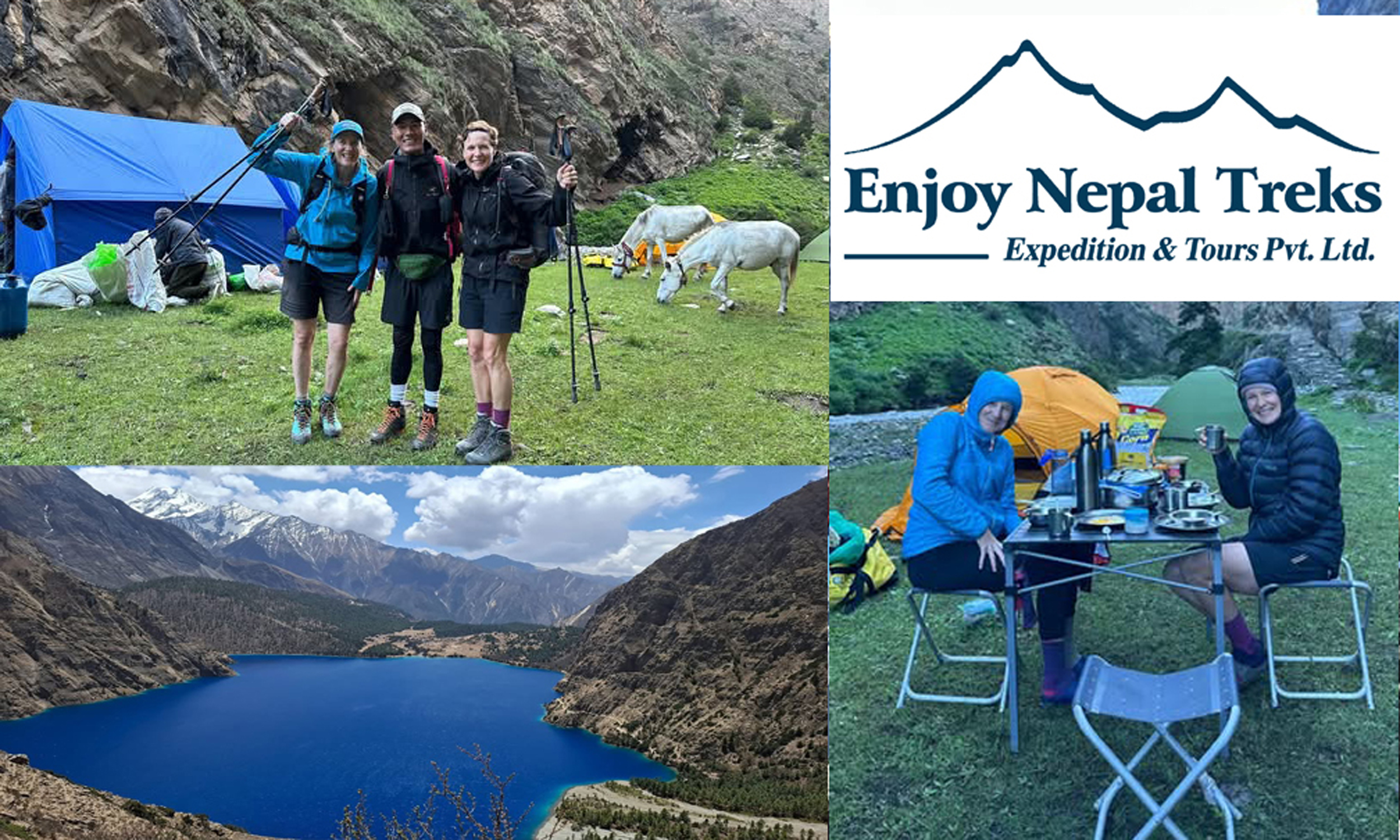
Enjoy Nepal Treks Expedition and Tours Pvt.Ltd a local Dolpo-based company, founded by people from the region. Strong focus on authentic cultural experience and supporting local communities. Good for: Local experience, cultural immersion, experienced Dolpo guides in Nepal since 2017 as Legally Register Agency in Nepal.
Upper Dolpo Trek Reviews
Here’s a clear, realistic summary of Upper Dolpo Trek reviews from trekkers and expedition reports:
Overall Impression
Most reviews describe the Upper Dolpo Trek as one of the most remote, wild, and culturally untouched treks in Nepal. It is often called a “once-in-a-lifetime expedition” rather than a normal trek.
Trekkers consistently mention:
Extremely remote and quiet trails
Very few or no crowds
Strong Tibetan-influenced culture
Dramatic Himalayan landscapes and high passes
⭐ What trekkers LOVE
1. Unmatched wilderness
Many say it feels like stepping into another world:
Huge empty valleys
Desert-like mountain scenery
Deep silence and isolation
One review calls it “a hidden gem of Nepal with unmatched scenery and peacefulness”
2. Shey Phoksundo Lake (highlight)
Almost every review mentions this as the most beautiful part:
Bright turquoise lake
Surrounded by cliffs
Very spiritual and peaceful atmosphere
3. Culture & people
Strong Tibetan Buddhist and Bon traditions
Ancient monasteries like Shey Gompa
Friendly but very traditional local lifestyle
4. True adventure feeling
Trekkers often describe it as:
“real expedition trekking”
camping-based journey
physically and mentally challenging but rewarding
Common challenges mentioned in reviews
1. Very difficult trek
Long walking days (6–7+ hours)
High passes above 5,000m
Rough and rocky trails
2. No luxury facilities
Very few lodges in upper region
Mostly camping supported treks
Limited communication and medical access
3. Weather & altitude
Cold nights even in trekking seasons
Risk of altitude sickness
Weather can change suddenly
4. Expensive & restricted area
Requires special permits and guide
Not allowed for solo trekking
Final review summary
Most trekkers rate Upper Dolpo as:
✔ One of the most beautiful treks in Nepal ✔ Extremely challenging but unforgettable ✔ Best for experienced trekkers who want true wilderness
But also:
❌ Not suitable for beginners ❌ Physically demanding and logistically complex
If you want, I can also give:
Real trek cost breakdown (agency + permits + camping)
Day-by-day itinerary reviews (what people liked or disliked)
Upper Dolpo vs Upper Mustang comparison
Best trekking agencies based on real feedback
Why select Enjoy Nepal Treks for upper dolpo Trek
Choosing Enjoy Nepal Treks for the Upper Dolpo Trek is mainly about reliability, local expertise, and personalized support in one of Nepal’s most remote regions. Based on traveler feedback and their trekking operations, here are the key reasons people select them:
Experienced local guides for remote Dolpo terrain
Upper Dolpo is one of the most isolated trekking regions in Nepal, with high passes, limited villages, and difficult logistics. Enjoy Nepal Treks provides experienced guides who already work in major high-altitude regions like Dolpo, Manaslu, and Everest, which is crucial for safety and navigation in such terrain.
Strong reputation from real trekkers
Reviews show consistent praise for:
Professional and knowledgeable guides
Safe trekking management
Good organization of permits and logistics
Flexible itineraries based on trekker needs
This matters a lot for Upper Dolpo because plans often change due to weather, altitude, or trail conditions.
Customized Upper Dolpo itineraries
Upper Dolpo is not a “fixed package” trek in practice. A good agency must adjust:
Route length (20–30 days typical)
Acclimatization days
Camping vs lodge logistics
Enjoy Nepal Treks is known for tailor-made trekking plans instead of rigid group schedules, which suits Dolpo perfectly.
Full logistics handling (very important in Dolpo)
For Upper Dolpo, you need complex arrangements:
Restricted area permits
Camping gear and kitchen setup
Porters/yaks support
Food supply in remote sections
They handle these logistics so trekkers can focus on the journey instead of planning difficulties.
Local support and safety management
In Upper Dolpo, there are:
Long isolated walking days
Limited medical access
High passes above 5,000m
Having a local company with strong field coordination helps with emergency response, altitude management, and route decisions.
Cost-value balance
Compared to international operators, local companies like Enjoy Nepal Treks often provide:
Lower cost
More flexible customization
Direct communication with the organizer (no middle agents)
In short:
People choose Enjoy Nepal Treks for Upper Dolpo because they combine experienced local guides + strong logistics handling + flexible private trekking design, which is exactly what a remote trek like Dolpo requires.
25 days Upper Dolpo Jomsom Trek how many km?
The 25-day Upper Dolpo–Jomsom Trek is a long and remote trans-Himalayan journey, and the total distance can vary slightly depending on the exact route, acclimatization days, and side trips (like to Shey Gompa or Crystal Mountain).
Typical Distance
Total trekking distance:~320 km to 380 km
Average per day (walking days): 15–22 km
Total walking days: around 20–22 days (rest are acclimatization / travel days)
Route Overview (common version)
Start: Juphal (Dolpo)
Pass through: Dunai → Dho Tarap → Numa La → Baga La → Shey Gompa → Saldang → Namgung → Phoksundo Lake
Exit toward: Jomsom (via high passes like Jungben La or alternative routes)
Why distance varies
Different itinerary designs (some include more exploration days)
Alternate passes or shortcuts
Campsite choices in remote areas
Reality check
Even though ~350 km is a good average estimate, this trek feels much longer due to:


Leave a Reply