Yes, a Manaslu Circuit Trek price of US$900 per person can be realistic for a budget group package, especially if you join a group and use standard teahouse accommodation. Recent trekking cost guides place budget/group departures around US$900, while most standard guided packages range from US$900 depending on services and season.
11 days Manaslu Trek cost or price is 900$
What a US$900 Manaslu Trek Package Usually Includes
Required trekking permits (RAP, MCAP, and ACAP)
Licensed trekking guide
Basic teahouse accommodation
Breakfast, Lunch and Dinner during the Manaslu Trek
Ground transportation from and back to Kathmandu (Local)
Group trekking arrangement
Government taxes and service charges
Enjoy Nepal Treks Duffel Bag
First aid kit
Trekking Map
Trekking Itinerary
Enjoy Nepal Treks Cap
Airport Pick up and drop
Usually Not Included
Nepal visa fees
Travel insurance
Personal expenses (Wi-Fi, charging, hot showers, drinks tea, Coffee etc)
Tips for guide and porter
Trekking equipment rental
Hotel and Meals in Kathmandu
Porter: If you need Porter, Our Porter cost will be 300$ extra Charge for 1 Porter
Trekking Equipments
Private Tourist Jeep ktm to Machhakhola: Private Tourist Jeep cost is 250$ in Reserve
Private Tourist Jeep Dharapani to kathmandu: Private Tourist Jeep cost is 350$ in Reserve
Private Tourist Jeep Besisahar to kathmandu: Private Tourist Jeep cost is 250$ in Reserve
11 Days Manaslu Circuit Trek Itinerary
Day 1: Kathmandu to Machha Khola
Drive: 8–10 hours by jeep/Bus
Distance: Approximately 160 km
Overnight: Machha Khola (930 m)
Distance and Driving Time
Distance: Approximately 160–170 km
Driving Time:8–10 hours depending on road and weather conditions
This is a moderate trekking day with several ascents and descents, but no technical challenges. Good fitness and steady pacing are recommended.
Day 3: Jagat to Deng
Trek: 6–7 hours
Distance: 20 km
Overnight: Deng (1,860 m)
The trek from Jagat to Deng is one of the most scenic sections of the Manaslu Circuit Trek.
Distance: Approximately 19–22 km Walking Time: 6–7 hours Starting Elevation (Jagat): 1,340 m Ending Elevation (Deng): 1,860 m Elevation Gain: About 520 m
Route Highlights
Trek through beautiful forests and traditional Gurung villages.
Pass the large village of Philim, known for its terraced fields and mountain views.
Continue via Ekle Bhatti and narrow river gorges.
Cross several suspension bridges over the Budhi Gandaki River.
Enter increasingly remote landscapes as you approach Deng.
Experience a gradual transition from Gurung culture to Tibetan-influenced communities.
Typical Itinerary
Jagat → Philim (2–3 hours)
Philim → Ekle Bhatti (1–2 hours)
Ekle Bhatti → Deng (3–4 hours)
Day 4: Deng to Namrung
Trek: 6–8 hours
Distance: 19 km
Overnight: Namrung (2,630 m)
The Deng → Namrung section is one of the most scenic and important transitions on the Manaslu Circuit Trek, as you move from lower Gurung villages into more Tibetan-influenced high Himalayan terrain.
Deng to Namrung Trek Overview
Distance: ~19–22 km (varies by route/side trails)
Trekking time: 6–8 hours
Starting point: Deng (~1,860 m)
Ending point: Namrung (~2,630 m)
Net ascent: ~700–800 m
Difficulty: Moderate to challenging (long day + altitude gain)
Trail Description
1. Deng → Rana / Bihi area
You start with a mix of forest trails, suspension bridges, and small settlements. The trail gradually climbs and crosses the Budhi Gandaki valley multiple times.
Bamboo forests and river crossings
Small villages like Bihi and Rana
Increasing Buddhist influence (mani walls, chortens)
2. Bihi → Ghap
This section becomes more peaceful and less crowded.
Steeper uphill sections
Dense pine and rhododendron forests
Occasional landslide-prone stretches
3. Ghap → Namrung
Final climb of the day.
Noticeable change in culture (Tibetan-style houses)
Better mountain views begin appearing
Strong ascent before reaching Namrung village
Highlights of This Section
Transition into Upper Manaslu cultural zone
First clear views of Manaslu range peaks (weather permitting)
Beautiful forest-to-alpine environment shift
Rich Buddhist heritage (mani walls, prayer flags everywhere)
Trekking Tips
Start early (it’s a long walking day)
Carry enough water (fewer teahouses between Ghap and Namrung)
Expect steep climbs after Ghap
Watch for leeches in monsoon season
Acclimatization starts becoming important here
Day 5: Namrung to Samagaon
Trek: 6–7 hours
Distance: 18 km
Pass through Lho and Shyala
Overnight: Samagaon (3,530 m)
The trek from Namrung to Samagaon is one of the most beautiful and important sections of the Manaslu Circuit Trek, as you enter higher alpine valleys and get your first close views of Manaslu.
Route Description
The trail climbs gradually through Tibetan-influenced villages and scenic ridges:
Namrung → Lihi → Lho → Shyala → Samagaon
Namrung to Lho: Steady uphill through forests and stone villages
Lho: Famous monastery and first strong views of Mount Manaslu
Lho to Shyala: Open alpine section with wide mountain panoramas
Shyala: One of the best viewpoints of Manaslu, Himalchuli, and Ngadi Chuli
Shyala to Samagaon: Gentle descent into a wide valley with monasteries and yak pastures
What makes this section special
First full, close view of Mount Manaslu (8,163 m)
Strong Tibetan Buddhist culture (mani walls, chortens, monasteries)
Transition from forested valley to high alpine landscape
Arrival at Samagaon, one of the largest and most important villages on the trek
Difficulty
Moderate overall, but easier than earlier river gorge sections. The main challenge is altitude, not terrain.
Day 6: Acclimatization Day at Samagaon
Optional hike to Manaslu Base Camp or Birendra Lake
Overnight: Samagaon
An Acclimatization Day at Samagaon (≈3,520 m) on the Manaslu Circuit Trek is a planned rest-and-short-hike day that helps your body adjust to thinner air before you move higher toward Samdo and Larkya La Pass.
Why this day is important
Samagaon is your first major high-altitude village, and the next sections of the trek rise quickly. Spending a full day here reduces the risk of altitude sickness by allowing your body to adapt gradually .
The idea is simple: climb higher during the day, sleep at the same altitude (“climb high, sleep low” principle).
What you typically do on this day
1. Short hike to Birendra Lake (easy option)
Distance: short half-day walk
Altitude: around 3,450–3,500 m
A calm glacial lake with mountain reflections
Good for light walking and recovery
This is the most relaxed option and very popular for acclimatization .
2. Hike to Pungyen Gompa (moderate option)
A beautiful monastery above Samagaon
Offers wide views of Manaslu and surrounding peaks
Cultural experience + steady uphill walk
This is great if you want a mix of nature and local Tibetan-influenced culture .
3. Manaslu Base Camp hike (hard option)
Long day (5–7 hours round trip)
Altitude up to ~4,400–4,800 m
Close-up view of Manaslu Glacier and massive peaks
This is the most rewarding but physically demanding acclimatization hike .
Rest of the day
After the hike:
Rest in the teahouse
Hydrate well
Eat properly (carbs help at altitude)
Avoid overexertion or alcohol
Light walking around the village is fine
You’ll also notice Samagaon itself is interesting:
The trek from Samagaon to Samdo is one of the key acclimatization stages on the Manaslu Circuit Trek, and it’s a relatively short but very scenic high-altitude walk.
Trail overview
The trail gradually climbs out of Samagaon and follows the Budhi Gandaki valley, passing through open alpine landscapes, yak pastures, and dry high-mountain terrain. Trees become sparse, and the valley feels wider and more Tibetan-influenced as you approach Samdo.
You’ll typically:
Cross mani walls and small streams
Walk past Kermo Kharka grazing areas
Cross a wooden bridge over the Budhi Gandaki River
Follow a gentle uphill ridge into Samdo village
What Samdo is like
Samdo is a small Tibetan-influenced village near the Nepal–Tibet border. It’s the last major village before the high pass section, and it’s often used for another rest/acclimatization stop. The views around Samdo include surrounding peaks and open glacial valleys.
Difficulty
Easy to moderate
Short walking day but at high altitude, so slow pace is important
Day 8: Samdo to Dharamsala
Trek: 4–5 hours
Distance: 7 km
Overnight: Dharamsala (4,460 m)
The trek from Samdo to Dharamsala (Larke Phedi) is one of the most important high-altitude sections of the Manaslu Circuit, as it leads you closer to the Larkya La Pass.
Trail Overview
The trail starts with a gradual climb above Samdo village
You cross dry river valleys and moraine landscapes
Path becomes more rocky, windy, and exposed as you gain altitude
No forests here—only alpine desert terrain with views of snow peaks
Difficulty
Moderate to challenging (due to altitude, not distance)
Main difficulty is thin air and cold winds
Weather can change quickly even in pre-monsoon/post-monsoon seasons
Highlights
Wide views of Manaslu range and surrounding glaciers
Chance to spot blue sheep and Himalayan birds
Peaceful, remote high-mountain environment
First real feeling of approaching Larkya La Pass (5,160 m)
Important Tips
Take it slow—this is a key acclimatization stage
Drink plenty of fluids (hydration is critical above 4,000 m)
Start early to avoid afternoon winds
Stay warm—Dharamsala is basic and very cold at night
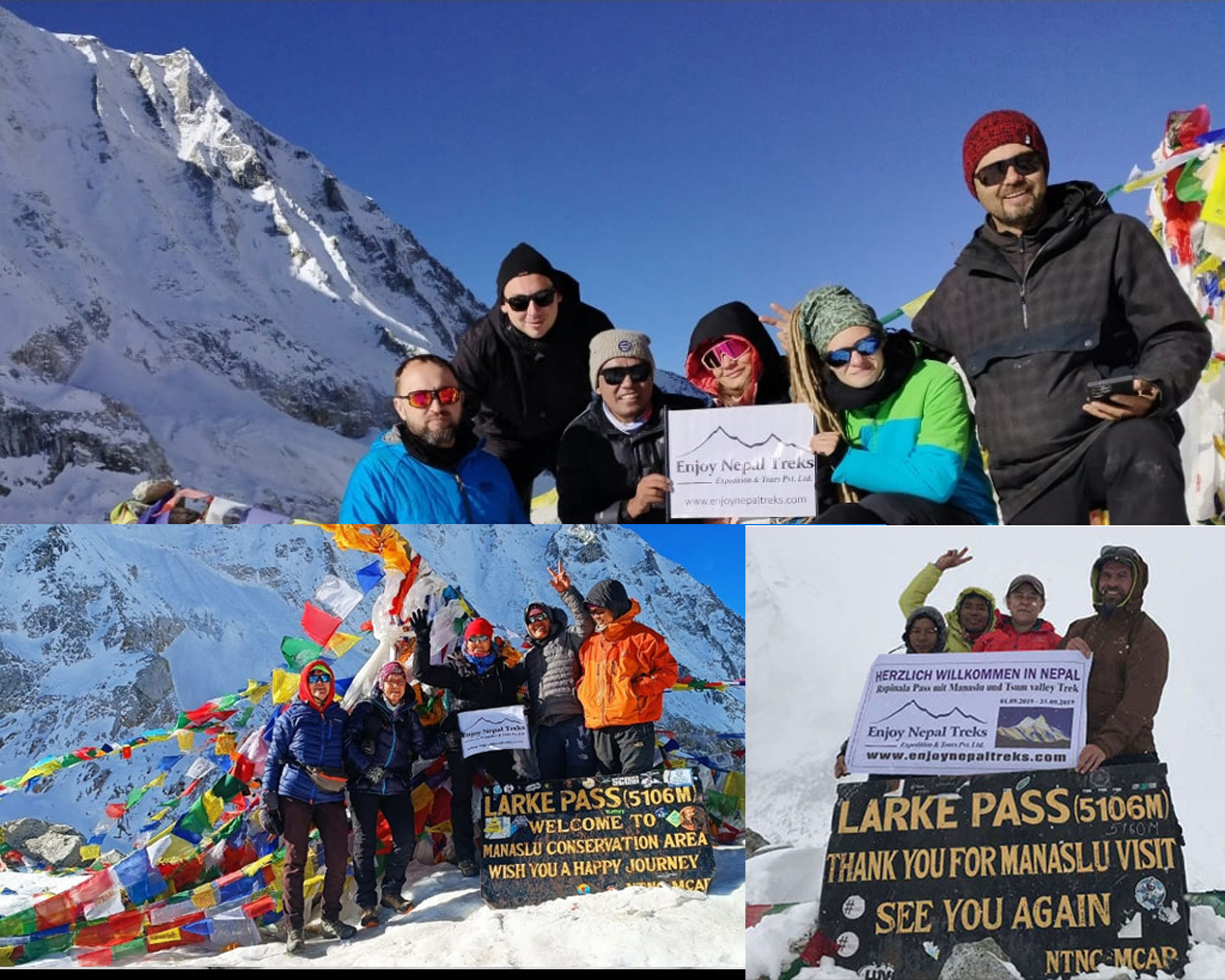
Day 9: Dharamsala to Bimthang via Larkya La Pass
Trek: 8–10 hours
Cross Larkya La Pass (5,106 m)
Overnight: Bimthang (3,720 m)
Distance: ~23–25 km
The Dharamsala (Larkya Phedi) to Bimthang via Larkya La Pass section is the toughest and most dramatic day of the Manaslu Circuit Trek. This is the key high-altitude crossing of the entire trek, linking the Manaslu side with the Bimthang valley.
Early start (around 3–5 AM)
You leave Dharamsala in the dark with headlamps. The goal is to reach the pass before strong winds and clouds build up.
Ascent to Larkya La Pass
Steep climb over rocky moraine and sometimes snow
Thin air makes even slow walking tiring
The final section to the pass is the hardest mentally and physically
At the top:
Prayer flags
Views of Manaslu, Himlung Himal, Annapurna II, Cheo Himal
Very strong winds (short stay only)
Descent to Bimthang
This is long and demanding:
Steep scree slopes (hard on knees)
Glacier/moraine crossings
Gradual change into green valleys near Bimthang
By the end, you reach:
Alpine meadows
Forested valley
Teahouses in Bimthang for rest
Difficulty level
Very high difficulty day
Biggest challenge: altitude + long descent
Requires good acclimatization from Samagaon & Samdo
Day 10: Bimthang to Dharapani
Trek: 6–7 hours
Distance: 24 km
Overnight: Dharapani (1,860 m)
The Bimthang → Dharapani stretch is the final descent of the Manaslu Circuit / Manaslu–Annapurna connector trail, passing through beautiful alpine forest, river valleys, and traditional villages.
Trail Description
1. Bimthang to Yak Kharka / Gho
Steep descent through rhododendron and pine forests
Crossing glacial streams and wooden bridges
First stop often at Gho village
2. Gho to Tilije
Gradual descent with mixed forest and farmland
Passing traditional Gurung settlements
Tilije is a good lunch/rest point
3. Tilije to Dharapani
Short uphill sections followed by a long descent
Trail joins the Annapurna Circuit route
Final stretch follows the Marsyangdi River valley to Dharapani
Highlights
Dramatic change from alpine landscapes to lush subtropical forest
Waterfalls, suspension bridges, and river valleys
Traditional villages like Gho and Tilije
Reaching Dharapani, a major trekking junction (Manaslu + Annapurna)
Difficulty
Moderate to tiring (mainly long downhill strain on knees)
No technical climbing, but steep sections require care
Trekking poles highly recommended
Day 11: Dharapani to Kathmandu
Drive by jeep: 8–10 hours
Distance: ~230km (depending on route via Besisahar or direct off-road sections)
End of trek in Kathmandu
The Dharapani → Kathmandu journey is the final return route after treks like the Manaslu Circuit or Annapurna region. It’s a long travel day involving rough mountain roads and multiple vehicle changes.
Dharapani → Besisahar (Jeep)
4WD local jeep (mandatory due to rough road)
Duration: 2/3 hours
Road: Very bumpy, river-side off-road sections
Shared or private jeep options available
Besisahar → Kathmandu (Bus/Jeep)
Comfortable highway drive
Duration: 6–8 hours
Route: Prithvi Highway via Dumre → Muglin → Kathmandu
Manaslu Trek Gear & Equipment List
1. Clothing (Layer System – Most Important)
Manaslu has hot low valleys and freezing high passes, so layering is essential.
4-season sleeping bag (around -10°C to -15°C rated)
Sleeping bag liner (optional but useful)
Lightweight travel pillow (optional)
6. Trekking Accessories
Trekking poles (highly recommended for Larkya La)
Headlamp + extra batteries
Sunglasses (UV protection, snow glare)
Water bottles (2–3 liters capacity) or hydration bladder
Water purification tablets or filter
7. Personal Hygiene & Toiletries
Toothbrush, toothpaste
Biodegradable soap
Wet wipes
Hand sanitizer
Toilet paper
Quick-dry towel
Sunscreen (SPF 50+)
Lip balm with SPF
8. First Aid & Health Kit
Basic first aid kit
Painkillers (e.g., ibuprofen)
Anti-diarrheal medicine
Blister care (very important)
Rehydration salts
Personal prescription medicines
9. Electronics & Documents
Passport + trekking permits
Power bank (very important)
Phone + charging cable
Universal adapter
Camera (optional + spare battery)
10. Food & Miscellaneous
Energy bars / snacks
Cash (Nepali rupees – no ATMs on trail)
Lightweight books or cards (optional)
Ziplock bags for waste protection
Important Packing Tips
Pack light but don’t skip warm layers
Avoid cotton (it stays wet and cold)
Everything above 3,500m can be freezing
Rent gear in Kathmandu if needed (sleeping bag, down jacket, etc.)
Manaslu Trek Temperature by Altitude
Lower areas (700–2,000 m)
Day: 18°C – 30°C
Night: 10°C – 18°C
➜ Warm, humid in lower river valleys
Mid altitude (2,500–3,800 m)
Day: 5°C – 15°C
Night: -3°C – 5°C
➜ Cold mornings and nights, crisp daytime weather
High altitude (4,000–5,100 m, Larkya La Pass)
Day: -10°C – 5°C
Night: -15°C or lower (winter)
➜ Very cold, windy, snow possible
Temperature by Season
Spring (March–May)
Day: 10°C – 20°C (lower areas)
Higher regions: -5°C – 10°C
Clear mornings, cold nights, rhododendron blooms
Summer / Monsoon (June–August)
Day: 15°C – 30°C (lower trails)
High areas: 5°C – 15°C
Warm but very rainy, humid, slippery trails
Autumn (Sept–Nov) ⭐ Best season
Day: 10°C – 20°C (lower areas)
High areas: -10°C to 10°C
Clear skies, stable weather, cold nights
Winter (Dec–Feb)
Day: 0°C – 10°C (lower valleys)
High altitude: -10°C to -25°C
Heavy snow, extreme cold, Larkya La often closed
Simple Summary
Warmest: lower trails in monsoon
Best balance: autumn & spring
Coldest: winter at high altitude
Biggest challenge: freezing nights above 3,500 m
Manaslu Trek Highlights
The Manaslu Circuit Trek is one of Nepal’s most spectacular Himalayan adventures, combining remote wilderness, rich culture, and dramatic mountain scenery. Here are the main highlights:
1. Mount Manaslu (8,163m) Views
Mount Manaslu Throughout the trek, you get close-up views of the world’s 8th highest mountain. The best views appear from Lho, Samagaon, and Pungyen Gompa, where the peak dominates the skyline.
2. Larkya La Pass (5,160m)
Larkya La Pass The highest point of the trek and the biggest challenge. Crossing this high mountain pass rewards you with panoramic views of Himlung Himal, Cheo Himal, Annapurna II, and Manaslu range. It’s the most dramatic section of the entire route.
3. Authentic Himalayan Villages
Villages like Machha Khola, Jagat, Namrung, Lho, Samagaon, and Samdo show a strong cultural transition:
Lower region: Gurung & Magar villages, terraced fields
Upper region: Tibetan Buddhist culture, stone houses, prayer wheels, monasteries
4. Tibetan Buddhist Culture
The trek is filled with spiritual landmarks:
Ancient monasteries (gompas)
Mani walls carved with prayers
Prayer flags and chortens
Daily Buddhist traditions in villages like Lho and Samagaon
This cultural shift is one of the most memorable parts of the trek.
5. Birendra Lake & Glacial Landscapes
Birendra Lake A short hike from Samagaon leads to this stunning turquoise glacial lake surrounded by ice and mountains—perfect for acclimatization day exploration.
6. Budhi Gandaki Gorge
Budhi Gandaki River The lower trail follows deep river gorges, suspension bridges, waterfalls, and cliffside paths. This section feels wild, remote, and adventurous.
7. Manaslu Base Camp Side Trip
From Samagaon, trekkers can hike toward Manaslu Base Camp (4,800m) for even closer glacier and mountain views. It’s one of the best side hikes of the entire trek.
8. Wildlife & Conservation Area
Inside the Manaslu Conservation Area, you may spot:
Himalayan tahr
Musk deer
Blue sheep
Himalayan marmots
(rarely) snow leopard
9. Remote & Less Crowded Trails
Compared to Everest or Annapurna, Manaslu remains much quieter. This means:
More peaceful trekking experience
Fewer trekkers on the trail
More authentic teahouse stays
10. Constant Changing Landscapes
One of the biggest highlights is how quickly the scenery changes:
Subtropical forests → deep gorges → alpine valleys → snowy high pass terrain It feels like walking through several different worlds in one trek.
food and drinks in Manaslu Trek
On the Manaslu Circuit Trek, food and drinks are simple but filling, designed to give you energy for long walking days in high altitude. You’ll mainly eat in tea houses (lodges) along the trail.
Here’s what you can expect:
Main Food Options on Manaslu Trek
1. Dal Bhat (Most important meal)
Dal Bhat
Rice + lentil soup + vegetables + pickles
Sometimes comes with potato curry or greens
Usually refillable (free extra servings in many lodges)
Best choice for energy and stamina
Eaten for lunch or dinner almost every day
2. Noodles & Soups
Fried noodles (vegetable, egg, or cheese)
Soup noodles / Thukpa (Tibetan-style noodle soup)
Garlic soup (popular at high altitude)
These are warm, light, and good for cold weather.
3. Momos (dumplings)
Momo
Steamed or fried dumplings
Filled with vegetables, cheese, or sometimes meat
One of the most popular trekking snacks/meals
4. Potatoes, rice & pasta dishes
Fried rice / egg fried rice
Boiled or fried potatoes
Pasta / macaroni / spaghetti (simple versions)
These are common “quick energy” foods on the trail.
Breakfast Options
Tibetan bread (often with jam, honey, or eggs)
Pancakes (banana, apple, chocolate, etc.)
Porridge (oats or barley)
Eggs (boiled, fried, omelette)
Breakfast is usually light but carb-heavy for trekking energy.
Drinks on the Manaslu Trek
Hot drinks (very common)
Milk tea / black tea (Nepali “chiya”)
Ginger tea
Lemon tea / honey tea
Coffee (usually instant)
Hot chocolate
Hot drinks are very important for warmth and hydration.
Water (very important)
Boiled water (safest option in tea houses)
Filtered or treated water (with tablets or filters)
Bottled water (available but more expensive at higher altitude)
Staying hydrated is essential for avoiding altitude sickness.
Cold drinks (limited but available)
Soft drinks (Coke, Sprite, Fanta) in lower villages
Packaged juice
Occasionally beer in lower areas (not recommended at altitude)
Important Trek Food Tips
Food becomes more expensive as you go higher
Menus get smaller at higher villages (like Samdo, Dharmashala)
Eat freshly cooked food only
Avoid heavy meat at high altitude (not always fresh supply)
Carry snacks like energy bars, nuts, chocolate
Simple Summary
On the Manaslu Trek you mainly eat:
Dal Bhat (main energy food)
Momos
Noodles & soups
Pancakes & bread
hot drinks
Altitude Sickness in Manaslu Trek
Altitude sickness (Acute Mountain Sickness, AMS) is one of the main risks on the Manaslu Circuit Trek because the trail climbs quickly from low river valleys to very high passes above 5,000 m.
Why altitude sickness happens on Manaslu Trek
As you ascend, air pressure drops and your body gets less oxygen. On the Manaslu route, altitude increases rapidly:
Start: ~700–900 m (Soti Khola / Machha Khola)
Key villages: 2,000–3,500 m
High point: Larkya La Pass (5,160 m)
Because the climb is continuous and remote, acclimatization is critical.
Common symptoms of AMS
Symptoms usually appear above 2,500–3,000 m:
Headache (most common)
Nausea or vomiting
Dizziness or loss of balance
Fatigue, weakness
Loss of appetite
Poor sleep
Severe forms:
HAPE (fluid in lungs): breathlessness at rest
HACE (brain swelling): confusion, loss of coordination
High-risk points on the trek
You should be especially careful at:
Samagaon (3,500 m) → major acclimatization stop
Samdo (3,860 m)
Dharamsala (Larkya Phedi) (4,460 m)
These are the places where AMS often starts if trekkers ascend too quickly.
How to prevent altitude sickness
1. Acclimatize properly
Spend at least 1–2 nights in Samagaon
Do a short hike (like Manaslu Base Camp viewpoint or Pungyen Gompa)
2. Follow “climb high, sleep low”
Day hikes higher, sleep lower when possible
3. Slow ascent rule
Above 3,000 m: increase sleeping altitude by 300–500 m per day
4. Hydration & diet
Drink 3–4 liters water daily
Avoid alcohol and smoking
Eat high-carb meals
5. Medication (optional)
Some trekkers use Acetazolamide (Diamox) for prevention (only after medical advice)
What to do if symptoms appear
Stop ascending immediately
Rest at same altitude or descend
Drink fluids
If symptoms worsen → descend at least 500–1,000 m
Seek medical help if breathing or confusion occurs
Key takeaway
The Manaslu route is beautiful but fast altitude gain makes AMS very common if you rush. Proper acclimatization in Samagaon and Samdo is the single most important factor for a safe trek.
Limit weight for Porter in Manaslu Trek
For the Manaslu Circuit Trek, porter weight limits are set to protect their safety and are fairly standard across trekking agencies in Nepal:
Porter weight limit (Manaslu Trek)
Maximum legal/ethical limit:20–25 kg total per porter
Most responsible trekking agencies (recommended): about 20–22 kg
Per trekker share (usually 2 trekkers per porter):
10–12 kg per person (duffel bag)
Practical breakdown
Duffel bag (carried by porter): ~10–12 kg per trekker
Daypack (you carry): ~5–8 kg (water, jacket, snacks, camera, etc.)
Important notes
The porter’s load includes your main gear: sleeping bag, clothes, boots, and shared equipment.
Going above 25 kg is considered unsafe and unethical in most cases.
Why insurance is important for Manaslu Trek
The Manaslu region is very remote, with no road access in most sections and no nearby hospitals. If something goes wrong, the only realistic evacuation is a helicopter rescue, which can cost around USD 3,000–6,000+ .That’s why trekking agencies in Nepal almost always require proof of insurance before starting the trek.
Trekking permits (arranged via agency)
You cannot trek Manaslu independently for permits—you must apply through a registered trekking agency.
You will need:
Manaslu Restricted Area Permit (RAP) (main permit)
Manaslu Conservation Area Permit (MCAP)
Annapurna Conservation Area Permit (ACAP)
Sometimes Chumnubri Rural Municipality fee is also added
Electricity and Internet in Manaslu Trek (Updated Overview)
The Manaslu Circuit Trek is remote, but you are not completely disconnected. Electricity and internet exist along most of the route, but they are limited, slow, and unreliable—especially at higher altitude.
Electricity (Charging)
✔ Where electricity is available
Lower villages (Soti Khola → Jagat → Deng → Namrung):
Mostly reliable lodge electricity
Charging points in dining areas or reception
Mid villages (Lho, Samagaun):
Electricity mainly from solar or micro-hydro
Still usable but limited
High altitude (Samdo, Dharamsala/Larkya Phedi):
Very limited electricity
Often solar only
Charging may depend on weather
Charging cost
Usually NPR 100–600 per device
Higher you go → higher price and less availability
Important tips
Bring a 20,000 mAh power bank
Carry a universal adapter
Charge whenever you get a chance in lower villages
Internet / Wi-Fi
✔ Wi-Fi availability
Found in many teahouses in:
Jagat
Namrung
Lho
Samagaun (often best connection)
Usually paid Wi-Fi in most lodges
Cost
Around NPR 300–500 per login/device
Some places charge more in remote areas
Quality
Very slow (not like city internet)
OK for:
Messages (WhatsApp, Viber)
Basic browsing
Not good for:
Video calls
Uploading photos/videos
Remote work
Mobile network (extra useful info)
Best SIM: Nepal Telecom (NTC)
Works well up to Samagaun
After that → weak or no signal
Simple reality check
Lower trek: decent connectivity
Middle: patchy but usable
High passes: almost fully offline
Practical advice
If you’re trekking Manaslu:
Download offline maps (Google Maps / Maps.me)
Carry a power bank (very important)
Don’t rely on Wi-Fi for communication or work
Manaslu Trek Permit
For the Manaslu Circuit Trek, you need four permits/fees:
Manaslu Restricted Area Permit (RAP) – Mandatory
Manaslu Conservation Area Permit (MCAP) – Mandatory
Annapurna Conservation Area Permit (ACAP) – Mandatory
The Restricted Area Permit (RAP) must be obtained through a registered Nepali trekking agency.
Since March 2026, solo trekkers can obtain a Manaslu permit, but they still must trek with a licensed guide arranged through a registered agency.
Documents Required
Passport copy
Valid Nepal visa
Passport-size photographs
Travel insurance details (recommended)
Trekking itinerary and guide details
Guide is compulsory for Manaslu
Yes, a licensed guide is compulsory for the Manaslu Circuit Trek.
The Government of Nepal classifies the Manaslu region as a restricted area, so independent trekking is not permitted. To obtain the required permits, trekkers must:
Trek with a licensed Nepali guide.
Book through a registered trekking agency.
Have at least two trekkers in the permit application (the guide does not count as one of the two trekkers, although agencies can often pair solo trekkers with others).
Why is a guide mandatory?
Safety in remote mountain terrain.
Navigation through less-developed trails.
Assistance with altitude-related issues.
Compliance with restricted-area regulations.
0 Comments on
11 days Manaslu Trek cost or price is 900$


Leave a Reply